Difference between revisions of "Highmark"
From RocksfallWiki
(→Neighborhoods) |
|||
| (One intermediate revision by the same user not shown) | |||
| Line 64: | Line 64: | ||
===Neighborhoods=== | ===Neighborhoods=== | ||
| − | [[File:Highmarkneighborhoods.png| | + | [[File:Highmarkneighborhoods.png|800px|Map of Neighborhoods.]] |
| + | |||
| + | Anything 49-62 is fancy people neighborhoods. 63-67 are super fancy people/government. (Technically, 63 is a park) | ||
* 1. Undertow | * 1. Undertow | ||
* 2. West Clam | * 2. West Clam | ||
| Line 127: | Line 129: | ||
* 61. Uppercrest | * 61. Uppercrest | ||
* 62. Laurel Grove | * 62. Laurel Grove | ||
| − | * 63. Parliament Park | + | * 63. Parliament Park: an actual park |
* 64. North Crown | * 64. North Crown | ||
* 65. East Crown | * 65. East Crown | ||
Latest revision as of 12:22, 8 January 2023
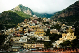
A cosmopolitan coastal city built in to the side of a mountain, Highmark is the political center of the Nerathi Confederacy. The human noble houses bearing the dragonmarks of Naming and Making are based in Highmark, as well as the famous Adventurer's Guild and Explorer's Union.
Governance
Like the Confederacy's government modeled after it, Highmark is ruled by two elected bodies, one legislative and one executive. The Chancellor of the Executive Council, Canto Jireh, likewise sits upon the Nerathi Council as Highmark's representative.
Population: approximately 750,000
Houses
| House | Race | Mark |
|---|---|---|
| Scrye | Human | Making |
| Factore | Human | Making |
| Doumens | Human | Naming |
| Jireh | Human | Naming |
| Machel | Human | Sentinel |
| Sarasset | Half-elf | Fraternity |
| Muranu | Tiefling | Binding |
| Aethelin | Dragonborn | Genesis |
| Kircher | Gnome | Images |
| Varades | Eladrin | Time |
| Falstaff | Halfling | Hospitality |
Neighborhoods
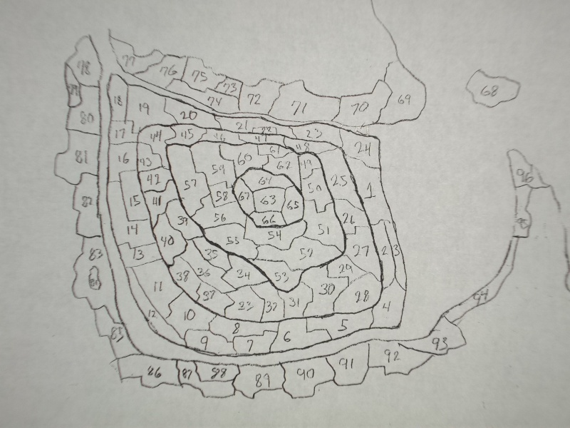
Anything 49-62 is fancy people neighborhoods. 63-67 are super fancy people/government. (Technically, 63 is a park)
- 1. Undertow
- 2. West Clam
- 3. East Clam
- 4. The Bends
- 5. South Market
- 6. Lower Quay
- 7. Everclear
- 8. Weirton (or Warton?)
- 9. Clayflats
- 10. Coppersmark
- 11. Newmarket
- 12. Southwall
- 13. Eelcreek
- 14.Westbank
- 15. Ortown
- 16. Bankside
- 17. Landslide Lanes
- 18.Watergate? Rivergate?
- 19. Anchor Point
- 20. Downslope
- 21. Upper Quay
- 22. Marrow
- 23. Fallsedge
- 24. Hope Falls (Falsehope)
- 25. Overlook
- 26. Eaglecrest
- 27. Fairmont
- 28. Moorcliff
- 29. Silver Corners
- 30. Cleftrock
- 31. Redstone
- 32. Haven
- 33. Midtown Markets (Midmarket)
- 34. Kingston Falls
- 35. Blackpool
- 36. Midway
- 37. Sunset Slope
- 38. Nilo’s Peak
- 39. Rocksprings
- 40. Lower Rocksprings
- 41. Magerun
- 42. Backshaft
- 43. Shadeside
- 44. Forkpoint
- 45. Upslope
- 46. Dagger’s Edge
- 47. Steepside
- 48. Clifton Heights
- 49. Prospect Point
- 50. Cold Spring
- 51. Dawnridge
- 52. Gladstone Gap
- 53. Clearview
- 54. Skytop
- 55. Sheerside
- 56. Fallingwater
- 57. Skyline
- 58. Highpark
- 59. Northview
- 60. Overhang
- 61. Uppercrest
- 62. Laurel Grove
- 63. Parliament Park: an actual park
- 64. North Crown
- 65. East Crown
- 66. South Crown
- 67. West Crown
- 68. Deep Isle
- 69. Sarcliffe
- 70. Highmist (Highsmoke)
- 71. The Narrows
- 72. Fleetwater
- 73. Saltmarsh
- 74. Elmridge
- 75. Greenshallow
- 76. Crescent Cove
- 77.East Fens
- 78.West Fens
- 79. Crookedbrook
- 80. Star Harbor
- 81. Holden’s Ford
- 82. Shanksville
- 83. Old Town
- 84 The Hole
- 85. West Bend
- 86. River Hill
- 87. Driftpile
- 88. Porter’s Ferry
- 89. Porterston
- 90. Gateway Docks
- 91. Pebble Shore
- 92. Caltrop
- 93. Cocklesbeach
- 94. East Docks
- 95. Golden Sands
- 96. Reina’s Point/Fort D’Arban


